


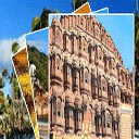


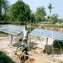


Meghalaya is a state in north-eastern India. The word "Meghalaya" literally means The Abode of Clouds in Sanskrit and other Indic languages. Meghalaya is a hilly strip in the eastern part of the country about 300 km long (east-west) and 100 km wide, with a total area of about 8,700 sq mi (22,720 km²). The population numbered 2,175,000 in 2000. The state is bounded on the north by Assam and by Bangladesh on the south. The capital is Shillong also known as the Scotland of the East, which has a population of 260,000. Meghalaya known as the ‘abode of clouds’ is one of the most beautiful state in the country. Nature has blessed the state with abundant rainfall, sun-shine, virgin forests, high plateaus, tumbling waterfalls, crystal clear rivers, meandering streamlets and above all with strong, intelligent and hospitable people. Meghalaya is predominantly an agrarian economy. The important crops of the state are potato, rice, maize, pineapple, banana etc. The important fruits currently grown in the state include citrus fruits, pineapple, papaya, banana etc. The mandarin orange grown in Meghalaya is considered to be of very high quality. In addition to this, a large variety of vegetables are grown in the state including cauliflower, cabbage and radish. Areca nut plantations can be seen all over the state, especially around the road from Guwahati to Shillong. Other plantation crops like tea, coffee and cashew have been introduced lately and are becoming popular. A large variety of spices, flowers, medicinal plants and mushrooms are also grown in the State.The service sector is made up of real estate and insurance companies. Meghalaya's gross state domestic product for 2004 is estimated at $1.6 billion in current prices. Shillong, the capital of the state, is a popular hill station.The maximum temperature in this region rarely goes beyond 28 °C (82 °F), whereas winters temperatures of sub-zero degrees are common. There are several falls in and around Shillong. The Shillong peak is highest in the state and is good for trekking. It is also known as the "abode of the gods" and has excellent views. If one is not in a mood for camping, the state also offers many good hotels and lodging facilities. Meghalaya is one of the Seven Sister States of India. The State of Meghalaya is also known as the "Meghalaya Plateau". It consists mainly of Archean rock formations. These rock formations contain rich deposits of valuable minerals like coal, limestone, uranium and sillimanite. Meghalaya has many rivers. Most of these are rainfed and are therefore seasonal. The important rivers in the Garo Hills Region are Daring, Sanda, Bandra, Bhogai, Dareng, Simsang, Nitai and the Bhupai. In the central and eastern section of the plateau, the important rivers are Umkhri, Digaru, Umiam, Kynchiang (Jadukata), Mawpa, Umiew or Barapani, Myngot and Myntdu. In the southern Khasi Hills Region, these rivers have created deep gorges and several beautiful waterfalls. There are lots of good schools and colleges in Shillong. As part of developmental program in north eastern states, ministry of human resource development opened the seventh Indian Institute of Management in Shillong which is named as Rajiv Gandhi Indian Institute of Management. This institute started admissions from the academic year 2008. Recently National Institute of Fashion Technology Shillong and NEIGRIHMS opened in Shillong. Shillong is fast turning up as the center of learning in the North Eastern region. Apart from Shillong, Good school and colleges are available in Jowai and Tura
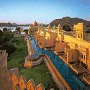
Shillong is the capital of Meghalaya. Its picturesque setting and salubrious climate were considered suitable for sanatoriums and holiday homes for British civilians, suffering from the sweltering heat of the plains. It is described as 'Mini London'. There are many legends surrounding the name Shillong. One says that it originated from the name of a handsome youth called Shyllong. Golf Links:Shillong's Golf Course is considered one of the best in India. It is situated in the center of the city, close to the polo ground. It was established in 1898, by a group of British Civil Service officers. Golfers from all over the world come here to test their skills. Lady Hydari Park:Lady Hydari Park was named after the wife of Sir Akhbari Hydari, the first Indian Governor of Assam who assumed charge on the eve of independence. It has a very attractive garden and the best months to see the flowers in bloom are April to October. Next to the park, is a mini zoo, where many species of birds and animals are kept. Museum of Entomology:This place is a treasure house of various kinds of exquisite Meghalayan butterflies and insects, some of which are bred and reared by naturalists and then preserved. The most beautiful and sought after Meghalayan butterfly is 'Kaiser-I-Hind'. Shillong Peak:Forested Shillong Peak, at 1,965 metres above sea level, acts as a vast catchment area. A steep winding road goes right to the top of the peak. On a clear day, you can see the Himalayan peaks and plains of Sylhet from the summit. Ward's Lake:This artificial lake located in Shillong received its name from Sir William Ward, Chief Commissioner of Assam in 1893-94, because he took a personal interest in beautifying it. Waterfalls:In and around Shillong, there are numerous waterfalls, especially during the monsoon when they run in milky white torrents: Bishop Falls, Elephant Falls, Spread Eagle Falls, Sweet Falls, Crinoline Falls and Beadon Falls are best known. Bishop or Suna Pani Falls are located west of Mawprem in Shilong. They are 135 metres high and particularly impressive in monsoon. The beautiful Elephant or Umdiengpun Falls are enroute to Sadew, 12 kilometres from Shillong City. Cherrapunjee:Cherrapunjee has a rich historical heritage and was the first British outpost in this part of the country. Sohra is the original Khasi name for Cherrapunjee. It is 1300 metres above sea level and 56 kms from Shillong. This place is one of the rainiest rain-belts in the world. A pleasant drive to see roaring waterfalls leaping into deep gorges, including the famed Nohsngithiang Falls. The lovely town is also famous for its limestone caves and orange honey. Centre of Khasi culture and literature, it also has the oldest Presbyterian Church and also an establishment of the Ramakrishna Mission. Mawsynram:56 Kms from Shillong, it is known for the giant stalagmite formation shaped into a Shivalinga, called locally as 'Mawjymbuin'. Jakrem:64 kms from Shillong, a popular health resort having hot-springs of sulphur water, believed to have curative medicinal properties. Monoliths in Khasi Hills:In the Khasi Hills are a number of ancient monoliths and table stones, which are either memorials where the ashes of the dead are deposited in cairns or cenotaphs, commemorating memorable events. The upright stones represent men generally and are of considerable size, sometimes projecting 6 metres (20 feet) or more above ground. Jowai in Jaintia Hills:The most important town in the Jaintia Hills district is Jowai, 1,380 metres above sea level, situated 64 kms from Shillong. The annual festival of Behdeinkhlam is celebrated in great style in Jowai. En-route from Shillong to Jowai, one passes through grassy meadows, colourful graveyards, rice terraces, woods of oak or whispering pine and the meandering Myntdu River. Nartiang:This is located in the Jaintia Hills about 65 kms from Shillong and 24 kms from Jowai. There are clusters of monoliths in Nartiang that are among the tallest anywhere in the world. Tura in Garo Hills:The district headquarters of the West Garo Hills is Tura, which is situated 657 metres above sea level. Tura has a picturesque landscape of hills overlooking the sweeping curves of the mighty Brahmaputra River on the plains below. The Tura Peak is very close to town and it is the ideal place for rock climbers, hikers and naturalists. Forming the western part of the State the entire Garo Hills having an area of approximately 8,000 sq kms. is densely forested and hence one of the richest spots in bioÂdiversity. The Garos predominantly inhabiting the three districts of the State namely East Garo Hills, West Garo Hills and South Garo Hills are basically superstitious, believe in spirits and have rich traditional tales of myths and legends. To the Garos everything that is interesting and unnatural has to have the lore of some kind. turaTura:Location: West Garo Hills District Tura the headquarter of West Garo Hills, which was also the headquarter of composite Garo Hills before two more districts of East and South Garo Hills were created, is 323 kms. from Shillong via Guwahati named after a powerful goddess Durama-Imbama, this Tura town is situated at the foot of Tura peak. 5kms higher at 1400m the peak offers some of the finest views of the hills against a backdrop of lowlying plains and sweeping curve of the mighty Brahmaputra. tura peakTura Peak:Location: West Garo Hills District A beautiful and majestic hill stands on the eastern side of Tura at a height of 872 m above sea level overlooking the town of Tura. Local legend has it that the peak provides a sacred shelter or abode to the ‘Gods’ and it is also claimed that Tura was traditionally known as Dura, but due to mispronunciation by the British gave it the present name of Tura. The Tura range has been declared a reserve forest with an observatory, a Cinchona plantation and a tourist bungalow located at its vicinity. A magnificent view of the lower Brahmaputra valley as well as the golden yellow plains of Bangladesh can be seen all year round from the peak. A foot-track or path developed during the British Raj is still in existence and can be used by tourists and adventurers alike to reach Tura peak with ease and comfort. nokrekNokrek Biosphere:Location: West Garo Hills District About 40 kms, via Asananggiri and Sasatgiri but just 2 kms. from Tura peak; teeming with wild life, Nokrek hill is the home of a very rare species of citrus locally known as Memang Narang orange of the spirits. This Memang Narang is considered to be the most primitive and progenitor of all other varieties of citrus plants in the world with a view to preserve this rare species of citrus indica the first gene sanctuary of the world has been established here. chibragreChibragre:Location: West Garo Hills District Lying at the confluence of Ganol and Rongram rivers, just 9 kms from Tura on the Tura Guwahati road is an ideal picnic spot. pelga fallsPelga Falls:Location: West Garo Hills District Pelga falls located at the distance of 7 kms from Tura has become increasingly hot spot for anglers and picnickers in recent years. The tourism department developed this place by constructing a footpath and view point. A typical traditional Garo bamboo bridge constructed over Ganol river is another added attraction. rongbang dareRongbang Dare:Location: West Garo Hills District Is another attractive tourist spot in West Garo Hills which can be easily viewed from Tura-Williamnagar PWD Road and the roadside near Rongbang dare virtually becomes mini bazaar in recent years where the Garos can dispose off their agriculture products besides running their indigenous food and tea stalls. sasatgreSasatgre Village:Location: West Garo Hills District Located on the hilly crescent-like saddle, at the foot of the Nokrek peak, in the West Garo Hills district, Sasatgre village is accessible by a jeepable road from Oragitok village which lies on the Tura-Asanangre-Williamnagar State highway. Sasatgre has been blessed by nature in so far as orange plantations are concerned and the village is surrounded by healthy, dark green orange bushes, which are highly productive. The village now falls on the periphery of the Nokrek Gene Sanctuary-cum-Biosphere Reserve. Bhaitbari:Location: West Garo Hills District This small sleeping hamlet of Bhaitbari came into national focus when ruins of ancient kingdom dating back to 4-8 A.D. were discovered here a few years ago. This place is just 8 kms. from Phulbari near Assam border and in nearer via plains road along Assam border and is nearer via plains road along Assam border. rangapaniRangapani:Location: West Garo Hills District 40 kms from Tura, near Mankachar on the Assam border there still lies the earthly remains of the great general Mir-Jumla the army general of great Moghul Emperor Aurangzeb. Mir-jumla died of malaria while returning from his excursions to the North - East. His tomb maintained by the local Muslim association lies in this village. williamnagarWilliamnagar:Location: East Garo Hills District Named after the 1st Chief Minister of Meghalaya, Capt. Williamson Sangma, this riverine town built on the curve of Simsang river is the Headquarters of East Garo hills. It is 313 kms from Shillone via Guwahati and is 76 kms from Tura. Rongrenggiri:Location: East Garo Hills District 5 kms from Williamnagar, is noted for being the last battle field where the Garos bravely resisted the British. Sisobibra:Location: East Garo Hills District 12 kms away from Williamnagar on the Tura Wiliamnagar road, a beautiful place on the banks of Simsang River is of historical importance, for it was here the legendary hero Togan Sangma along with his co-patriot Gilsang Dalbot fell to the bullets of the British soldiers while bravely resisting them. A memorial has been erected at the place where the warriors fell down. District Council has constructed a twin cottage near the memorial place where visitors can stay. Adokgre:Location: East Garo Hills District l0 kms from Duphdara on the Assam border, Adokgre was the first camp in Garo Hills when the Garos coming from Tibet under the leadership of Jappa-Jalimpa arrived the promised land of Garo Hills. It was here that they distributed the land according to their Machongs(clan). Naka-Chikong:Location: East Garo Hills District 15 kms from Duphdara, it is a big rock with deep hollows, in the middle of Ildek river in Badaka village just 3kms from Adokgre, this big rock is mythologically believed to be swarming with fishes, you can get tons of fishes any season of the year, but there is one belief, if any one inadvertently touches the big rock under whose hole the fishes are, all fishes immediately disappear from the river. The Hindus consider this a sacred place and regularly come here for worship and picnic. resubelparaResubelpara:Location: East Garo Hills District 15 kms from Williamnagar Sub-Divisional head quarter of Resu Sub-Division; there is a hot spring here. Napak:Location: East Garo Hills District 45 kms from Williamnagar there is a lake formed by damming of the upper tributary of a river during the great earth quake in 1897. Napak was once the land of the spirit until one woman working in the Jhum accidentally killed a spirit's baby. The spirits feeling insecure then migrated to Balpakram where they settled till now. baghmaraBaghmara:Location: South Garo Hills District Baghmara the head quarter of South Garo Hills District is a fast growing township. It is situated on the banks of Simsang river on the international Bangladesh border. Nearby just below the picturesque Dilsa hill, the State Tourism Department has constructed a Tourist bungalow. baghmara forestBaghmara Reserve Forest:Location: South Garo Hills District At a distance of about 4 kilometers from the main town of Baghmara, this thick forest is inhabited by langurs, birds of different species, elephants, etc. Many tourists have reported sighting herds of elephants as they travel from Baghmara to Balpakram National Park via Baghmara Reserve Forest. nengkongNengkong:Location: South Garo Hills District 14 kms north of Baghmara is the well known caves Tetengkol, which balwakol measuring 5,33kms in length is one of the longest cave in the Indian Sub-continent. The other cave is Dobakkol Chibe Nala almost 2kms long and another, a little over 1 km long called Bok-bak dobakkol are also in the vicinity of the area. sijuSiju:Location: South Garo Hills District 132 kms from Tura, Siju is famous for Dobakkol or the bat cave with impressive stalagmites and stalagtites. It is one of the longest caves in the Indian Sub-continent and contains some of the finest river passages to be found any where in the world. There are magnificent limestone rock formations inside, epecially named princes, Di's chamber by the excavators will fill any visitor with awe. Close by on the other side of Simsang River is the Siju bird sanctuary, a home for many rare and protected birds and other wildlife. The Siberian ducks also migrated here during the winter months. At the entrance to this bird sanctuary after a steep climb of nearly 1 km there is a stretch of fantastic rock formations that will take your breath away. balpakramBalpakram:Location: South Garo Hills District The literal meaning of Balpakram is the "land of perpetual winds". There is a great precipice or deep gorge in Balpakram and is popularly compared to the Grand Canyon of U.S.A. It is believed that here, the spirits of the dead dwell temporarily before embarking on the final journey. Balpakram is sacred to the Garos as the abode of the dead spirits. As mentioned earlier, the Garos are deeply spiritual and believe in myths as interesting and awe-some as the Greeks mythlogics. In support of their beliefs, Balpakram has many mysterious and unnatural phenomena that cannot be satisfactorily explained by modern science and logic. Some of these mysterious sites are Boldak matchu karam, Chidimak, Matchru, Areng patal, Goncho Dare, Dikkini ring, Rongsaljong Agal, Rongsobok Rongkol. Apart from the above mentioned sites there are many mysterious places which you can explore yourself. Indeed Balpakram is so steeped in myths that even the Hindus believe that it is a sacred place. They believe that when Laxman was seriously injured during the war with Ravana and a very rare life saving herb was required, Hanuman found it here but not knowing which to take also in his haste to return, broke the top of the hills and carried it away. The missing portion of that hill became a deep awning canyon. Balpakram has been declared a National Park some years ago. This place is about 220 sq kms in area and is 167 kms from Tura. This place is not only of mythological importance but also the natural habitant of many rare and exotic animals and plant life. It is also believed to be the original home of the rare citrus plant Me-mang Narang. Balpakram is exquisitely beautiful when ground orchids are in bloom. The best time to see is from November to March. There is the guest house at Hattisil at the entrance to Balpakram run by the Forest Department. imilchang dareImilchang Dare:Location: South Garo Hills District A waterfall of immense visual beauty is to be found close to the Tura-Chokpot Road in West Garo Hills district. The stream on which it is located, flows through a deep, narrow winding bed of crevice rocks till it suddenly emerges on to a broad wide opening and cascades in a thick, wide formation, over a broad chasm, creating an electrifying waterfall of unique beauty. The deep, wide pool at the bottom of the fall with its wide and expansive surroundings make it an exciting swimming pool, full of fish of varied size and colour, besides being an ideal picnic spot. Emangre:Location: South Garo Hills District This is the only village where the traditional wood carving on the posts and beams of the "Nokpante" or the bachelor's dormitory still survives. Dombeware:Location: South Garo Hills District 3 kms from Eman Asakgre there is a legendary lake on top of the hill believed to have been created by a merman when he eloped away with a beautiful wife of one boastful man. Some people say Bombe, the beautiful woman is still alive in the underground water Kingdom. simsang riverSimsang River:Simsang River starts from Nokrek peak and runs towards east, passing through Rongrengiri, Williamnagar, the headquarters of East Garo Hills district, Nongalbibra, Siju, Rewak and finally Baghmara, the headquarters of South Garo Hills district. Simsang river is known as Someshwari when it enters Bangladesh at Baghmara is the most magnificent and most prominent.

DTDC SHILLONG SORTING OFFICE (SO)
D&D MANSION BEHIND PARKING LOTS, QUINTON ROAD, POLICE
DTDC SHILLONG SORTING OFFICE (SO) in Shillong, Meghalaya


Dalu Barengapara P O , MEGHALAYA , 794103
Sacred Heart High School education services in MEGHALAYA
Dadenggiri P O , MEGHALAYA , 794104
St Theresas M E School education services in MEGHALAYA

07152 - 240338 / 240343
KESAMON HOUSE, IST FLOOR, LAITUMKHRAH, MAIN ROAD
Corporation Bank in Shillong, Meghalaya
- , MEGHALAYA , 793003
St Anthonys High School education services in MEGHALAYA
0364 - 2506573 / 2506574
S.NO.70, K.V.R. PLAZA, GIRI ROAD(NEAR GEETA BHAVAN)
Corporation Bank in Shillong, Meghalaya
Mawphlang , MEGHALAYA , 793121
Jawahar Navodaya Vidyalaya education services in MEGHALAYA
D-103, GALI NO. 5, LAXMINAGAR, DELHI
DTDC LAXMINAGAR (D-BLOCK) in East khasi hills, Meghalaya
B-11/1, KRISHNA NAGAR, NEW DELHI DELHI 110051 (DL)
DTDC KRISHNA NAGAR in East khasi hills, Meghalaya